Topcon 3D-MC² Masted Dozer System
Topcon 3D-MC² is a high-speed GNSS machine-control system designed to provide smooth and responsive automatic blade control for dozers.
The system uses a Topcon PG-S3 GNSS antenna mounted on a blade mast to provide the horizontal position and elevation. A dedicated MC² sensor monitors the movement and orientation of the blade. The MC-R3 combines this information with the recorded machine measurements to calculate the position and orientation of the cutting edge.
Cab Kit Components
- GX-55 touchscreen display.
- MC-R3 GNSS receiver and system communication HUB
- UHF radio
- 1 x Diamond Dual PG-S3 Pole mount
- 2 x PG-S3 GNSS Receivers
- 2 x Antenna Cables
The exact Cab Kit components can vary according to the dozer model, correction method and original installation.
Wiring Kit Components
- Blade-mounted mast and vibration pole.
- Single MC² sensor.
- MC² sensor mounting bracket and cable.
- Bonnet Junction box.
- UHF radio antenna and cable.
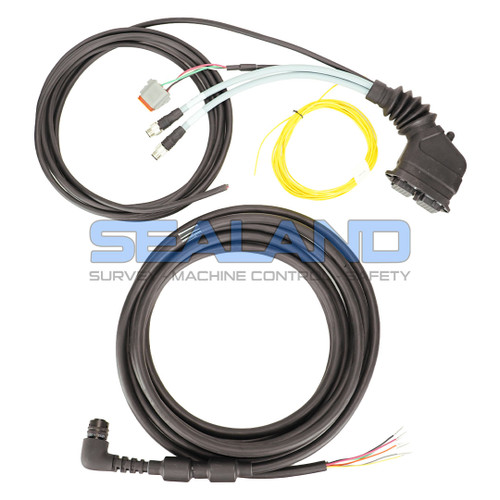
- Machine-specific power and communication harnesses.
- Machine-specific hydraulic-control interface.
- Hydraulic valve block where required.
The PG-S3 antenna provides the three-dimensional position of the mast reference point, while the MC² sensor provides the blade movement and orientation information required to calculate the cutting-edge position.
Topcon Sitelink3D Online Data Transfer and Remote Access
Sitelink is Topcon’s online, cloud-based data management and remote access platform.
To access Sitelink, users must first create a free MyTopcon account at www.topconpositioning.com.
Topcon machine control systems are supplied with a Topcon data SIM. Once activated, these SIM cards enable network connectivity and can be paired with Sitelink for remote access and file transfer (for more info on this, contact us). Sitelink connectivity is currently run on a per-point basis. Points can be purchased from our website and activated on My Topcon. Once Sitelink points have been activated, the Sitelink App will be accessible, and a unique support desk connection number will be provided.
Once your account is set up, data loaded to the online site can be synchronised to all Topcon machine control and Field Controllers. Tasks can be set for specific regions or individual machines, with updated design synchronisation, so everyone has the same data, thereby avoiding delays or costly mistakes.
Topo survey data can be recorded by individual machines or recorded on a layer set to be updated by all machines. This data can then be synchronised to Sitelink and downloaded for quality control or used to monitor progress.
Sitelink3D supports a range of Topcon, CAD and industry-standard design formats, including:
- TP3 – Topcon project file.
- TN3 – Topcon surface file.
- LN3 – Topcon linework file.
- GC3 – Topcon localisation file.
- DXF.
- DWG.
- LandXML.
- CSV.
- TXT.
For further information about Sitelink3D, account creation and Service Points, please see: [LINK]
Software Features
- Real-time blade cut-and-fill guidance.
- 3D blade positioning using the PG-S3 GNSS antenna.
- High-speed blade-control updates at up to 100 Hz.
- Automatic blade elevation and cross-slope control.
- Display of design surfaces, linework and project information.
- Vertical and horizontal working offsets.
- Steer-to-line guidance.
- Adjustable on-grade tolerances.
- USB transfer of supported project and design files.
- Remote file transfer through Sitelink3D where supported.
- Integrated horizontal and vertical LED guidance on the GX-55.
- Storage of multiple projects and machine configuration files.
Typical Uses
Topcon 3D-MC² is suitable for bulk earthworks, cut-and-fill operations, rough and final grading, platform construction, road formation, embankments, batters, quarry work and landfill applications where smooth automatic grading at increased working speeds is required.
Software
- Topcon 3D-MC v12.2.536
Available Configurations and Upgrades
Depending on the MC-R3 specification, RTK corrections may be received from an onsite Topcon base station using a compatible UHF radio or through a supported network connection.
The radio frequency, correction format and communication equipment must be compatible with the base station or network service being used.
Important Notes
- The PG-S3 provides the horizontal position and elevation of the mast reference point.
- The MC² sensor provides the blade movement and orientation information.
- GNSS and MC² sensor data are combined to calculate the cutting-edge position.
- The MC² sensor replaces the conventional 9620 Blade Slope Sensor.
- Automatic control requires a compatible dozer and hydraulic-control interface.
- Software and firmware compatibility must be checked before carrying out an update.
- Current Sitelink3D operation depends on the installed software, communication equipment and available mobile network.
- Used, transferred or repaired systems should be inspected, measured and recalibrated before being used for automatic grading.


 No
No  Yes
Yes